docs.unavlab.com
Main ❯ Navigation & tracking systems ❯ Device specification: RedNAV - navigation receiver for divers
 |
|
|---|---|
| www.unavlab.com support@unavlab.com |
RedNAV - diver’s navigation receiver Device specification |
KEY FEATURES
- Completely acoustically passive device
- 3D-position in absolute geographic coordinates (WGS-84)
- Update rate of 3D position up to 1 Hz
- Completely acoustically passive device
- Minimum dimensions and weight
- Simultaneous operation of an unlimited number of devices
- Reliable and noise-immune technology of digital broadband acoustic communication
- Automatic track saving with ability to export to KML and CSV formats
- Possibility to preload the route and save the current position
- Bluetooth connection and wireless charging
DESCRIPTION
RedNWAVE - the only system to date that implements the so-called “underwater GPS”: following exactly the ideology of GPS and other satellite systems, allows an unlimited number of underwater objects to determine their geographical location at the same time.
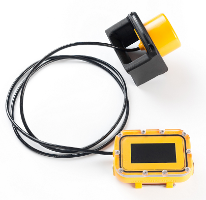
RedNAV - the diving navigation receiver of the system RedWAVE, which allows the diver to determine his geographical position when immersed, without the need for surfacing and using remote GPS antennas on the cable.
With the support of four floating sonobuoys RedBASE, it is possible in one water area simultaneous operation of an unlimited number of devices RedNAV and RedNODE.
Working with a navigation receiver RedNAV is in many ways similar to working with conventional GPS/GLONASS trackers and navigators, with the difference that the role of satellites is performed by four small-sized sonobuoys RedBASE. The device is mounted on the diver’s wrist and the hydroacoustic antenna on the shoulder or tank.
The unique functionality and ease of use make RedNAV an ideal solution for both recreational diving and search diving. archaeological and underwater engineering works.
Fully wireless pairing with PC via Bluetooth and wireless charging makes it extremely easy to maintain and reliable.
TECHNICAL SPECIFICATIONS
| PARAMETER | VALUE |
|---|---|
| DIMENSIONS (ACOUSTIC UNIT, Ф х h) | 64 x 64 mm |
| DIMENSIONS (INTERFACE UNIT) | 84 х 118 х 36 mm |
| WEIGHT (dry) | 0.65 kg |
| BATTERY LIFE | 8 hours |
| MAX. RELATIVE VELOCITY | +/- 1.8 m/s |
| WORKING TEMPERATURE RANGE | -5 .. 50 °С |
| DEPTH RATING | 70 m |
| MAX SIZE OF WORKING AREA | 700 х 700 m inside a polygon of buoys |
| ACOUSTIC RANGE (ENEGRY)1 | 3000 m |
| CARRIER | 20100 Hz |
| SNR2 | -6 dB |
| REFERENCE ELLIPSOID | WGS-84 |
| NOMINAL 2D-ACCURACY3 (2DRMS) | 0.84 m |
| NOMINAL DEPTH ACCURACY4 | 0.1 m |
| MINIMAL TIME TO FIRST POSITION FIX | 28 s |
| NOMINAL POSITION UPDATE RATE | 1 Hz |
| RATED STARTUP TIME | 3 s |
| BUILT-IN TEMPERATURE SENSOR ACCURACY | 0.1 °C |
| PAIRING WITH PC | Bluetooth |
| CHARGER | Wireless |
| BUILT-IN BATTERY TYPE | Li-Ion |
| CABLE LENGTH | 1.2 m |
| ROUTE FUNCTIONS | Up to 20 pre-loaded waypoints + up to 20 marked points |
| TRACK AUTOSAVING | Up to 2 hours5 |
| ADDITIONAL FUNCTIONS | Depth, Water temperature |
1 A parameter that determines the maximum range at which a signal can be received, based on
electro-acoustic parameters of the transmitter and receiver, spatial decrease in the intensity of sound energy, attenuation in the
medium and the acoustic noise level.
2 The value obtained without taking into account the multipath effect.
3 The value is obtained by measuring in a real water body with buoys and navigation receiver fixed, within 60 minutes.
4 The value may depend on the correctness of the user setting the salinity of the water.
5 During continuous operation of the device, taking into account the position update rate of 1 Hz.